Thursday, December 30, 2004

Coalpits Wash hike in Zion National Park

Finding unique Zion National Park trails that can be done in the dead of winter is not always easy, but it is possible. Today my friend Bo and I headed to the southern most corner of Zion Park to hike the Coalpits Wash trail. Coalpits is well known as the lowest elevation in the park at 3666'/1117m. The round trip is 14 miles so if you are going to do it in the winter you need to start early and hussle.

To find the trailhead drive 7.3 miles past the south gate at the park. You will go through Springdale and Rockville to an area that most do not even know is part of Zion Park. You will see a wash with a small green sign, Coalpits, indicating the name of the wash under the bridge. Pull off and park in the dirt area and look to the north for the hikers gate. There is a map at the trailhead, but not much more information. They do allow pack animals on this trail, but the park reserves the right to disallow it different times of the year depending on trail conditions and weather.

The first part of the trail is not very intersting as you pass by powerlines, sagebrush and the trail is far enough from the water at this point that you will not see that. Before too long you will see volcanic, or Basalt rock on the left. To the right the trail, still far from the water, will pass near some low rock formations. In front of you is Cougar Mountain and until you start to walk along the streambed that is the extent of the scenery. This is not a very scenic hike compared to the rest that Zion offers, and the hike is not very challenging because of the lack of elevation, but for a winter hike it is nice. If you do it in the summer watch for rattlesnakes. The cougar tracks made me erie and to top it off as we passed the big 90 degree bend we past an area that would make a great cougar den and it smelled strong of cat oder.

The narrow dirt trail will go along one side of the stream or the other. Going across the stream is required, but unless you fall your shoes should stay dry. There are plenty of stepping stones to use to cross the stream. The Coalpits Wash trail will be joined twice. Once by the Chinle Trail and once by the Scoggins Trail. These areas are not obvious however.

About an mile or so from the end of the trail are some historic oil ruins. These are considered historic artifacts and should not be touched. They are left over from the early 1900s before this area was made part of the park. Continue another mile to mile and a half past the oil remains where the trail will end. The only way any further is by technical climbing. At the end of the trail there are some nice falls between two unamed tributaries and a nice four foot waterfall at the very end.


Zion National Park

Complete Trail Description and Photo Album

Coalpits Hike

Zion National Park hiking guide

Zion National Park Hiking

Tuesday, December 14, 2004

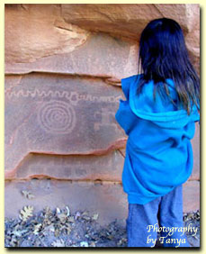
Petroglyph Canyon in Zion National Park is a nice little Rock Art site. Posted by Hello

Zion National Park Petroglyphs (Rock Art)

This week we explored three different Rock Art sites in Zion National Park. The first stop was Sacrifice Rock. This large flat stone is located near the south entrance to the park, across the road from the campground. Look up at the rocks on the side and you should notice a small NPS sign. This site has been horribly vandalized and has lead the NPS to ask those of us who know where Rock Art is to keep it quiet, but this site has been "sacrificed" to the general public and is open to viewing.

The next site in Zion National Park we went to visit was in Petroglyph Canyon. The park does allow visitation to this site, but only after talking with a ranger at the Zion Canyon Visitors Center. This is a fun little spot that is only a short walk off the main highway in Zion. The petroglyphs are on the bottom of a large cliff. If you do get directions, take the time to explore the upper canyon. It ends in a rock slide, but there is some great scenery and boulder hopping along the way.

The final site we went to visit is in Spry Canyon. This involves a stressful uphill hike into Zion's backcountry. The petroglyphs here are faded from exposure, but graffiti free!

Zion National Park

Complete Trail Description and Photo Album

Zion National Park History

Zion National Park hiking guide

Zion National Park Hiking

Thursday, December 09, 2004

The hike up to Spry Canyon from Upper Pine Creek is a steep one. Photo is on the hike back down. Posted by Hello

Monday, December 06, 2004

Upper Pine Creek to Spry Canyon

Winter is Zion is spectacular, but there is nothing like getting into the backcountry to see the frozen waterfalls and icicles. This hike began just east of the Zion Mt. Carmel Tunnel. From the tunnel, pass Shelf Canyon, the first route and go to the next. This is Upper Pine Creek. Drop down into the creek, looking for a good place to climb up to the top. The best place we found is opposite of the dark cave far up on the right. The hike up is steep and can be dangerous and scarey in spots. Don't take children and be sure to wear good, sticky hiking shoes if you go. Once at the top the veiws are impressive. The West Temple is straight ahead. See if you can see the horse head in the West Temple.

Slick rock mountains tower all around the climb up location. Pine trees spot the rock and the landscape is magnificent. Continue the hike downward toward Spry Canyon. This is where the hike ends. If you are interested in Canyoneering look at www.climb-utah for more information.

This was a fun hike with two good friends, Bo and Tim. Thank you guys for taking me up to Spry Canyon!

Zion National Park

Complete Trail Description and Photo Album

Zion National Park

Zion National Park hiking guide

Zion National Park Hiking

Tuesday, November 09, 2004

Red Cave Slot Canyon east of Zion National park

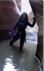
This was a great trip! I felt very safe today since I got the chance to hike and canyoneer with two Search and Rescue men from Kane County and a Search and Rescue Vetran from Zion National Park. Bo and I met for breakfast at the Thunderbird and we met up with Mark and Dean at 9am. Although the forcast called for some light scattered showers it had been raining all night and it only let up a short time the entire day we hiked. First questions was where were we going, and Mark got a smile on his face and said how about Red Cave. Since it was raining that was a good idea. We did not want to let the slot have time to flood. After talking to my brother we decided the best way to go was through Tait Lane in Mount Carmel. Although there is a wild 4WD road that is entered through his yard there is now a locked gate past his house on anothers property. We did not see anyone to stop and ask if we could go so we drove slowly and made sure to shut the gate behind us. The road pretty much leads to the slot and Dean knows the 4WD areas well so we easily made it to Upper Red Cave. We stopped and checked out the entrance but with the cold temperature outside, the rain and the fact we would have to get pretty wet at the start of the slot we decided to go and check out Lower Red Cave. We were in luck and found that slot to be totally dry and it was sand filled to my delight. I had been through the slot earlier in the Summer with Shane Burrows and the boulder obstacles were not easy at that time. Today on the otherhand, they were a breeze. Right at the start of the slot is a rope obstacle. Climb this frayed ancient rope at your own risk! The climb seems easy for the men, but I had to take the alternate route and go around the right side of the slot and hike up the mountain side and find a way down. Bo, the gentleman he his went with me and found us a nice spot to enter the slot. We got down and did not find Mark and Dean anywhere so we hiked back to the rope area to find them just 15 ft past the rope obstacle at another fun obstacle. After a quick look at it, and the face that we did not bring any rope, the guys decided that they too would go out and hike up the mountain side and drop into the slot.

The rest of the slot was easy with sand laid down high in the last flash flood. I have no doubt with all the rain we are having this week that the slot will be flooding again soon and each time the characteristics of the slot change. We made our way through the beautiful and skinny slot, past the window and the open area into another nice slot section. When we got to the end we were cold enough we turned around and went back rather than hiking over to the upper section and going in that from the back and having to hike back to the Rover all wet.

This was an outstanding day with awesome friends!

Thanks Bo, Dean and Mark!

Zion National Park

Complete Trail Description and Photo Album

Zion National Park

Zion National Park hiking guide

Zion National Park Hiking

Kane County Search and Rescue Vice Commander Dean Kurtz and Search and Rescue member Mark in the incredible Red CAve Slot Canyon located on the east side of Zion National Park. Posted by Hello

Saturday, November 06, 2004

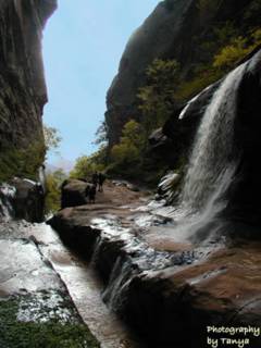
Water Canyon is a wonderful hike located on the east side of Zion National Park. The trail over Water Canyon leads to an impressive view of Zion National Park. Posted by Hello

Tuesday, November 02, 2004

Water Canyon - Impressive Slot Canyon

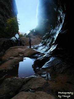
This weekend I returned to the Canaan Mountain hike, but this time I spent more time in the slot canyon section called Water Canyon. My timing was perfect because it had been raining for days and snow was melting so the waterfalls were spectacular and abundant. I was with a group of four men, one old friend Bo, and three new friends. Our first obstacle was getting past the muddy dirt road that led to the trail. After one truck got stuck we decided to park on the paved road and lug our gear down the 1.5 mile dirt/mud road. It was well worth the trek. When I had been here just a couple of week earlier I could walk up parts of the slot without gettting the upper parts of my shoes wet, but that was not the case today.

I was glad I had wore my water tennies and neoprene socks within the first few minutes. The waterfalls were so beautiful we spent a lot more time in Water Canyon than we had planned, along with the trek down the muddy road. Noon was already approaching so we decided we had better head up to the rest of the hike. The trail up to the top is very steep and the deep snow on the trial added to its difficulty. The exercise felt great though and we quickly made it to the top of the mountain.

I was the only one in the group that had been there before so I pointed out the way. They all looked at me as I explained that we just head sort of in "that direction" and that there is not trail for the rest of the hike. The snow was deep and we had changed out of our water shoes along the trail. Our hiking boots were not saturated and my toes were already cold.

Changing shoes and checking our supplies we were prepared to brave the unexpected deep snow. We rushed through this cold part of the trip and hurried back down the trail. The snow had been melting during this time and the waterfalls were now gushing like crazy. It was spectaucular! It took us a long time just to get down the trail because we had to stop and oh and ah at all the waterfalls that had begun to pour since we had come up in the morning. My camera already had over 100 shots on it. We made it back down to the slot and played in the waterfalls and took for picures. Just amazed at how much more the water was now flowing. We debated getting out the canyoneering gear, but it was getting dark so we decided we should come back when it was warmer.

Thanks for the trip guys

~tanya

Zion National Park

Complete Trail Description and Photo Album

Zion National Park

Zion National Park hiking guide

Zion National Park Hiking

Tuesday, October 26, 2004

The view from the Chinle Trail in Zion National Park. Posted by Hello

Chinle Trail - Zion National Park Hike

October 2004

It had been pouring rain in Zion National Park for the last week and was getting cold toward the last of October so the Chinle Trail was an ideal trail for the day. I went out with a group of new friends and ran into one old friend along the trail who was hiking alone.

This is not the most spectacular trail in Zion and it would be a hot trail during the summer due to the low elevation it is sitting at but for a late fall hike it was enjoyable. There has also been a new sub-division built at the trailhead which could be avoided but we parked at the old trailhead and made our way past the new Anasazi Plateau home development.

To find the trailhead drive away from the park to the farthest end of Springdale where the fruit stand and apple orchard are found. By the way, this is a wonderful place to pull into and get a snack. The shop is unique and they sell healthy and fresh foods.

From the fruit stand continue up highway 9 for about a block and turn in on the paved road. Follow the uphill short road taking an immediate right at the top and park in the lot. Follow the dirt path up the hill and under the bridge to the gate. Make sure to close the gate behind you. The official trail and NPS boundaries begin at this point.

This trail does not get a lot of traffic, and it would not be on my top 20 list for Zion, but everything in Zion is magnificent and this trail was no different. Hike along the wash until you see the dirt road. Take the road instead of following the wash at the fork. The first wash you will come upon is Huber Wash which leads to the Petrified Forest. The next wash along the trail is Scoggins Wash before the trail heads up to the land between Scoggins and Coal Pits Wash before finally leading into Coal Pits.

There is a nice view of Zion's West Temple and Mt. Kinesava and the forest sprinkled with driftwood is fun. While hiking in the area you can hike down into one of the washes like we did and do some exploration. There is Coalpits, Huber and Scoggins Washes.

The Chinle Trail is a 16.4 mile round trip hike with little elevation (950 ft.) change.


Zion National Park

Complete Trail Descriptions and Photo Album

Chinle Trail

Zion National Park hiking guide

Zion National Park Hiking

Tuesday, October 12, 2004

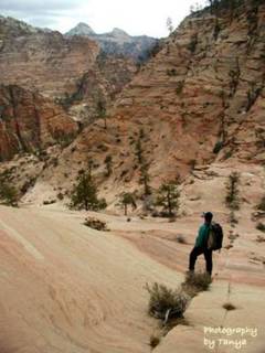
Water Canyon Trail east of Zion National Park leads to an impressive view of the park. Posted by Hello

Hiking Canaan Mountain to a spectacular view of Zion National Park

This was a wonderful trip with my friend Dean Kurtz and three new friends Randy Cram, Mark Mallory and Mark E. I felt well protected on this adventure since all four men were search and rescue members of the Kane County Team.

The trip is about 12 miles with a 2,000 ft. elevation gain. This is a route that few know of so it’s unlikely you will meet other hikers. The route goes through a wonderful slot canyon section, past a waterfall, over wind swept slick rock, past volcanic rock and white hoodoos, moqui marbles, sand and then climbs to the top of the mountain where white hoodoos are abundant. The route ends at a “V” in the cliffs above the Cannon Ranch where an old windlass is found.

To find the trailhead from Fredonia, Arizona, drive towards Hilldale on AZ389. Turn east on Utah Avenue at the Mark Twain Restaurant. Follow Utah Avenue for a couple of miles until it leaves the residential area and nears the high cliffs. There are two dirt roads to the east, take the second dirt road to the reservoir.

The route begins along a small stream just past the reservoir and climbs steeply along Water Canyon. About forty-five minutes into the hike you will reach a magnificent slot canyon section. This section can be explored or you can continue the trek up the mountain side. The path is well trodden in this area, but narrow so watch your step and don't take kids.

If you intend to hike past this point I suggest that you have mapped out the route on a topo map. Hiking past this point is only for experienced hikers and good map readers.

At the top of the mountain is a large rock, some trees and the point where you will begin to hike downhill, for a short while, before heading up hill again. Look for the large white hoodoo domes in the distance and head in that direction. The domes sit on a large section of wind swept slick rock that looks like a white Paria. At the far end of the domes is a magnificent view of Zion National Park. You will be able to see the Kolob section, the Eagle Crags as well as the east side of the park.

The next two miles of the hike are lacking significant elevation change, but they are across a deep sandy road that was used when motorized vehicles were allowed on the path. Follow the road to the first large “V” in the mountain. Below the “V” you will be able to see the town below as well as AZ389. To find the windlass continue hiking to the next large “V” in the mountain side. There are more hoodoos in this section and the path is again over a dirt road.

Look for the Canaan Ranch on your map. The “V” is directly above it. You will be able to see the remnants of the windlass as you approach. The windlass is a giant spool for steel cable that was used by the settlers to lower lumber down to the settlement below.


A Windlass:
A machine for raising weights, consisting of a horizontal
cylinder or roller moving on its axis, and turned by a
crank, lever, or similar means, so as to wind up a rope or
chain attached to the weight. In vessels the windlass is
often used instead of the capstan for raising the anchor.
It is usually set upon the forecastle, and is worked by
hand or steam.


Thank you guys!

Zion National Park

Complete Trail Descriptions and Photo Album

Canaan Mountain and Water Canyon Hike

Zion National Park hiking guide
Zion National Park Hiking

Tuesday, October 05, 2004

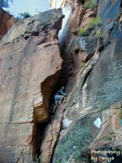
Bo Beck climbing the chimney on Lady Mountain in Zion National Park. Posted by Hello

Sunday, October 03, 2004

The great lady of Zion National Park

The early pioneers gave the mountains in Zion Canyon their names and Lady Mountain is no exception. This 6,945’ monolith was given her name because of the shape of a woman found in a section of the hike. Lady Mountain was a trail once that was open to the general public, equipped with safety chains and other safety devices much like those found along the Angels Landing Trail.

Imagine the women of the 1920’s in their heels and long dresses trudging up this steep trail. Between 1923 when the trail was made and 1960 when the trail was abandoned and the ladders and chains were removed, there were deaths and many rescues along this trail.

Lady Mountain is located across the highway from the Zion Lodge in Zion Canyon. It is the towering monolith seen at the entrance of the Emerald Pools Trail. This hike is not for everyone, in fact few do and should ever attempt it. Although I am among those that should not attempt the route (no longer a trail), our guides Tim and Bo Beck kept our friends and myself safe.

The park no longer maintains the route so the few that attempt the climb/hike must be experienced climbers. Joe Braun Sr., a member of our group, had hiked Lady Mountain when he was 21 years old, when the chains and ladders were in place. He did not recognize much of the hike as being the same.

The remnants of the trail now involve 4th and 5th class exposed climbs and pitches and the walking section of the trail is steep with slippery slopes and long drop offs. Our group was led by Bo Beck, a member of Zion’s search and rescue team, who has climbed Lady Mountain more than a dozen times. Bo was our lead climber and protecting our backside was Bo’s friend Tim Tabor, a Photography instructor at Dixie College and a 5.11 climber. The rest of the party was Joe Braun, who has a Zion photography site, his dad and myself. We met at the Zion Canyon Visitors Center at 7am on Saturday October 2nd. It was chilly in the morning for the first two hours which was ideal for this hot, sunny trek uphill. The descent of the hike is about 3,000’ in a little over 1 mile!

The first obstacle comes early in the hike (see the photo of Bo climbing), which would cause most to turn around and and find a safer hike. Bo scaled these precarious rocks like a cat and secured a safety line for the rest of us. Tim made sure every stayed safe from the back. After our first climb we were ready for anything.

We continued the uphill trek, climbing up the most precarious places I had ever imagined going, but we were always kept safe by Bo and Tim. Joe and his dad were characters and kept us all laughing and having a good time. I adore them and hope I get to spend more time with them in the future. The entire group was wonderful and I could not imagine spending the day with a better bunch of men!

The view from the top of the mountain was spectacular! Angels Landing was far below us. In front we could see Red Arch Mountain, the Great White Throne, Deer Trap Mountain, Cable Mountain, East Temple, West Temple and the Zion Lodge. To our left was Castle Dome (although we could not agree on which mountain it was)and Behunin Canyon. A antique dial sits on top of a stack of rocks pointing to the dominant monoliths viewed from the point.

We stayed at the top for quite some time, talking and enjoying each others company as well as the view before we began the steep descent. The problem with climbing up things is you have to go back down them eventually. We down climbed most of the places using a safety line that we had left behind during our ascent. Bo decided to give us all a climbing lesson on one of the tough spots. He assured us if we fell he would catch us. We all made it without him having to rescue us, to my amazement.

Bo must be quite the instructor! I knew I was going to fall, but I did not mind falling into his arms. The rocks were not as bad to climb down as the bottom part of the trail was to hike down. The slope was steep, sandy and covered in loose rocks. When we made it to the Middle Emerald Pools Trail my legs were wobbly. The hike/climb up to Lady’s Mountain is one that I will always remember and cherish.

Thank you – Bo, Joe, Joe Sr. and Tim!

Zion National Park

Complete Trail Descriptions and Photo Album

Lady Mountain Hike/Climb

Zion National Park hiking guide

Zion National Park Hiking

Joe Braun, Tanya Milligan and Bo Beck on the top of Lady Mountain in Zion National Park! Posted by Hello

Wednesday, September 15, 2004

Zion National Park Hike of the Week - Gifford Canyon

Gifford Canyon Hike
The best thing about Gifford Canyon is its a beautiful canyon in Zion that you will have to yourself! A friend, Bo Beck, talked about Gifford Canyon often so I wanted to go and see it. It's certainly a place that I will go to again. Thanks Bo!

Do not get on the Zion shuttle for this hike. Gifford Canyon is the starting point for the strenuous and technical trail to Bridge Mountain. While Bridge Mountain is not on the to do list for the average hiker, Gifford Canyon can be. The hike begins at the parking lot across the highway from the Canyon Overlook Trail. Make your way down the steep dirt path of use near the restrooms. Walk up stream for about 75 ft and climb the 15 ft. dry wash. At the top of the climb the trail is obvious. Just follow it as it winds around the mountain. It will widen once you are in Gifford Canyon. Hike up the sandy path to the end of the canyon. There are some nice views of various monoliths on the side of the trail and at the trails start and end. The trail is 3 miles round trip and takes about 2 hours to complete.

Note: check the weather report before hiking this canyon. There is a danger of flash floods.

Zion National Park

Complete Trail Description and Photo Album

Gifford Canyon Hike

Zion National Park hiking guide

Zion National Park Hiking

Tuesday, September 14, 2004

Zion National Park

Welome to the Zion National Park Blog


Zion National Park is one of the most incredible places in the world. It is a haven for hikers, climbers, canyoneers and tourists flocking to the park just to get a glimpse of the unique magnifences of this small corner of Southern Utah. The weather is as acccommodating for adventure as the landscape. Southern Utah boasts of clear skies and acceptable hiking temperatures for most of the year. Zion National Park is a treasure to behold. Embrace the recreation that the vertical topography of Zion Park offers.

Zion National Park

Zion National Park hiking guide
Zion National Park Hiking

Zion National Park Forum

Zion National Park Forum