Thursday, December 30, 2004

Coalpits Wash hike in Zion National Park

Finding unique Zion National Park trails that can be done in the dead of winter is not always easy, but it is possible. Today my friend Bo and I headed to the southern most corner of Zion Park to hike the Coalpits Wash trail. Coalpits is well known as the lowest elevation in the park at 3666'/1117m. The round trip is 14 miles so if you are going to do it in the winter you need to start early and hussle.

To find the trailhead drive 7.3 miles past the south gate at the park. You will go through Springdale and Rockville to an area that most do not even know is part of Zion Park. You will see a wash with a small green sign, Coalpits, indicating the name of the wash under the bridge. Pull off and park in the dirt area and look to the north for the hikers gate. There is a map at the trailhead, but not much more information. They do allow pack animals on this trail, but the park reserves the right to disallow it different times of the year depending on trail conditions and weather.

The first part of the trail is not very intersting as you pass by powerlines, sagebrush and the trail is far enough from the water at this point that you will not see that. Before too long you will see volcanic, or Basalt rock on the left. To the right the trail, still far from the water, will pass near some low rock formations. In front of you is Cougar Mountain and until you start to walk along the streambed that is the extent of the scenery. This is not a very scenic hike compared to the rest that Zion offers, and the hike is not very challenging because of the lack of elevation, but for a winter hike it is nice. If you do it in the summer watch for rattlesnakes. The cougar tracks made me erie and to top it off as we passed the big 90 degree bend we past an area that would make a great cougar den and it smelled strong of cat oder.

The narrow dirt trail will go along one side of the stream or the other. Going across the stream is required, but unless you fall your shoes should stay dry. There are plenty of stepping stones to use to cross the stream. The Coalpits Wash trail will be joined twice. Once by the Chinle Trail and once by the Scoggins Trail. These areas are not obvious however.

About an mile or so from the end of the trail are some historic oil ruins. These are considered historic artifacts and should not be touched. They are left over from the early 1900s before this area was made part of the park. Continue another mile to mile and a half past the oil remains where the trail will end. The only way any further is by technical climbing. At the end of the trail there are some nice falls between two unamed tributaries and a nice four foot waterfall at the very end.


Zion National Park

Complete Trail Description and Photo Album

Coalpits Hike

Zion National Park hiking guide

Zion National Park Hiking

Tuesday, December 14, 2004

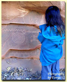
Petroglyph Canyon in Zion National Park is a nice little Rock Art site. Posted by Hello

Zion National Park Petroglyphs (Rock Art)

This week we explored three different Rock Art sites in Zion National Park. The first stop was Sacrifice Rock. This large flat stone is located near the south entrance to the park, across the road from the campground. Look up at the rocks on the side and you should notice a small NPS sign. This site has been horribly vandalized and has lead the NPS to ask those of us who know where Rock Art is to keep it quiet, but this site has been "sacrificed" to the general public and is open to viewing.

The next site in Zion National Park we went to visit was in Petroglyph Canyon. The park does allow visitation to this site, but only after talking with a ranger at the Zion Canyon Visitors Center. This is a fun little spot that is only a short walk off the main highway in Zion. The petroglyphs are on the bottom of a large cliff. If you do get directions, take the time to explore the upper canyon. It ends in a rock slide, but there is some great scenery and boulder hopping along the way.

The final site we went to visit is in Spry Canyon. This involves a stressful uphill hike into Zion's backcountry. The petroglyphs here are faded from exposure, but graffiti free!

Zion National Park

Complete Trail Description and Photo Album

Zion National Park History

Zion National Park hiking guide

Zion National Park Hiking

Thursday, December 09, 2004

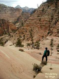
The hike up to Spry Canyon from Upper Pine Creek is a steep one. Photo is on the hike back down. Posted by Hello

Monday, December 06, 2004

Upper Pine Creek to Spry Canyon

Winter is Zion is spectacular, but there is nothing like getting into the backcountry to see the frozen waterfalls and icicles. This hike began just east of the Zion Mt. Carmel Tunnel. From the tunnel, pass Shelf Canyon, the first route and go to the next. This is Upper Pine Creek. Drop down into the creek, looking for a good place to climb up to the top. The best place we found is opposite of the dark cave far up on the right. The hike up is steep and can be dangerous and scarey in spots. Don't take children and be sure to wear good, sticky hiking shoes if you go. Once at the top the veiws are impressive. The West Temple is straight ahead. See if you can see the horse head in the West Temple.

Slick rock mountains tower all around the climb up location. Pine trees spot the rock and the landscape is magnificent. Continue the hike downward toward Spry Canyon. This is where the hike ends. If you are interested in Canyoneering look at www.climb-utah for more information.

This was a fun hike with two good friends, Bo and Tim. Thank you guys for taking me up to Spry Canyon!

Zion National Park

Complete Trail Description and Photo Album

Zion National Park

Zion National Park hiking guide

Zion National Park Hiking