Tuesday, October 26, 2004

The view from the Chinle Trail in Zion National Park. Posted by Hello

Chinle Trail - Zion National Park Hike

October 2004

It had been pouring rain in Zion National Park for the last week and was getting cold toward the last of October so the Chinle Trail was an ideal trail for the day. I went out with a group of new friends and ran into one old friend along the trail who was hiking alone.

This is not the most spectacular trail in Zion and it would be a hot trail during the summer due to the low elevation it is sitting at but for a late fall hike it was enjoyable. There has also been a new sub-division built at the trailhead which could be avoided but we parked at the old trailhead and made our way past the new Anasazi Plateau home development.

To find the trailhead drive away from the park to the farthest end of Springdale where the fruit stand and apple orchard are found. By the way, this is a wonderful place to pull into and get a snack. The shop is unique and they sell healthy and fresh foods.

From the fruit stand continue up highway 9 for about a block and turn in on the paved road. Follow the uphill short road taking an immediate right at the top and park in the lot. Follow the dirt path up the hill and under the bridge to the gate. Make sure to close the gate behind you. The official trail and NPS boundaries begin at this point.

This trail does not get a lot of traffic, and it would not be on my top 20 list for Zion, but everything in Zion is magnificent and this trail was no different. Hike along the wash until you see the dirt road. Take the road instead of following the wash at the fork. The first wash you will come upon is Huber Wash which leads to the Petrified Forest. The next wash along the trail is Scoggins Wash before the trail heads up to the land between Scoggins and Coal Pits Wash before finally leading into Coal Pits.

There is a nice view of Zion's West Temple and Mt. Kinesava and the forest sprinkled with driftwood is fun. While hiking in the area you can hike down into one of the washes like we did and do some exploration. There is Coalpits, Huber and Scoggins Washes.

The Chinle Trail is a 16.4 mile round trip hike with little elevation (950 ft.) change.


Zion National Park

Complete Trail Descriptions and Photo Album

Chinle Trail

Zion National Park hiking guide

Zion National Park Hiking

Tuesday, October 12, 2004

Water Canyon Trail east of Zion National Park leads to an impressive view of the park. Posted by Hello

Hiking Canaan Mountain to a spectacular view of Zion National Park

This was a wonderful trip with my friend Dean Kurtz and three new friends Randy Cram, Mark Mallory and Mark E. I felt well protected on this adventure since all four men were search and rescue members of the Kane County Team.

The trip is about 12 miles with a 2,000 ft. elevation gain. This is a route that few know of so it’s unlikely you will meet other hikers. The route goes through a wonderful slot canyon section, past a waterfall, over wind swept slick rock, past volcanic rock and white hoodoos, moqui marbles, sand and then climbs to the top of the mountain where white hoodoos are abundant. The route ends at a “V” in the cliffs above the Cannon Ranch where an old windlass is found.

To find the trailhead from Fredonia, Arizona, drive towards Hilldale on AZ389. Turn east on Utah Avenue at the Mark Twain Restaurant. Follow Utah Avenue for a couple of miles until it leaves the residential area and nears the high cliffs. There are two dirt roads to the east, take the second dirt road to the reservoir.

The route begins along a small stream just past the reservoir and climbs steeply along Water Canyon. About forty-five minutes into the hike you will reach a magnificent slot canyon section. This section can be explored or you can continue the trek up the mountain side. The path is well trodden in this area, but narrow so watch your step and don't take kids.

If you intend to hike past this point I suggest that you have mapped out the route on a topo map. Hiking past this point is only for experienced hikers and good map readers.

At the top of the mountain is a large rock, some trees and the point where you will begin to hike downhill, for a short while, before heading up hill again. Look for the large white hoodoo domes in the distance and head in that direction. The domes sit on a large section of wind swept slick rock that looks like a white Paria. At the far end of the domes is a magnificent view of Zion National Park. You will be able to see the Kolob section, the Eagle Crags as well as the east side of the park.

The next two miles of the hike are lacking significant elevation change, but they are across a deep sandy road that was used when motorized vehicles were allowed on the path. Follow the road to the first large “V” in the mountain. Below the “V” you will be able to see the town below as well as AZ389. To find the windlass continue hiking to the next large “V” in the mountain side. There are more hoodoos in this section and the path is again over a dirt road.

Look for the Canaan Ranch on your map. The “V” is directly above it. You will be able to see the remnants of the windlass as you approach. The windlass is a giant spool for steel cable that was used by the settlers to lower lumber down to the settlement below.


A Windlass:
A machine for raising weights, consisting of a horizontal
cylinder or roller moving on its axis, and turned by a
crank, lever, or similar means, so as to wind up a rope or
chain attached to the weight. In vessels the windlass is
often used instead of the capstan for raising the anchor.
It is usually set upon the forecastle, and is worked by
hand or steam.


Thank you guys!

Zion National Park

Complete Trail Descriptions and Photo Album

Canaan Mountain and Water Canyon Hike

Zion National Park hiking guide

Zion National Park Hiking

Tuesday, October 05, 2004

Bo Beck climbing the chimney on Lady Mountain in Zion National Park. Posted by Hello

Sunday, October 03, 2004

The great lady of Zion National Park

The early pioneers gave the mountains in Zion Canyon their names and Lady Mountain is no exception. This 6,945’ monolith was given her name because of the shape of a woman found in a section of the hike. Lady Mountain was a trail once that was open to the general public, equipped with safety chains and other safety devices much like those found along the Angels Landing Trail.

Imagine the women of the 1920’s in their heels and long dresses trudging up this steep trail. Between 1923 when the trail was made and 1960 when the trail was abandoned and the ladders and chains were removed, there were deaths and many rescues along this trail.

Lady Mountain is located across the highway from the Zion Lodge in Zion Canyon. It is the towering monolith seen at the entrance of the Emerald Pools Trail. This hike is not for everyone, in fact few do and should ever attempt it. Although I am among those that should not attempt the route (no longer a trail), our guides Tim and Bo Beck kept our friends and myself safe.

The park no longer maintains the route so the few that attempt the climb/hike must be experienced climbers. Joe Braun Sr., a member of our group, had hiked Lady Mountain when he was 21 years old, when the chains and ladders were in place. He did not recognize much of the hike as being the same.

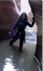
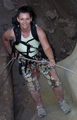
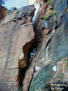
The remnants of the trail now involve 4th and 5th class exposed climbs and pitches and the walking section of the trail is steep with slippery slopes and long drop offs. Our group was led by Bo Beck, a member of Zion’s search and rescue team, who has climbed Lady Mountain more than a dozen times. Bo was our lead climber and protecting our backside was Bo’s friend Tim Tabor, a Photography instructor at Dixie College and a 5.11 climber. The rest of the party was Joe Braun, who has a Zion photography site, his dad and myself. We met at the Zion Canyon Visitors Center at 7am on Saturday October 2nd. It was chilly in the morning for the first two hours which was ideal for this hot, sunny trek uphill. The descent of the hike is about 3,000’ in a little over 1 mile!

The first obstacle comes early in the hike (see the photo of Bo climbing), which would cause most to turn around and and find a safer hike. Bo scaled these precarious rocks like a cat and secured a safety line for the rest of us. Tim made sure every stayed safe from the back. After our first climb we were ready for anything.

We continued the uphill trek, climbing up the most precarious places I had ever imagined going, but we were always kept safe by Bo and Tim. Joe and his dad were characters and kept us all laughing and having a good time. I adore them and hope I get to spend more time with them in the future. The entire group was wonderful and I could not imagine spending the day with a better bunch of men!

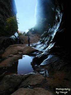
The view from the top of the mountain was spectacular! Angels Landing was far below us. In front we could see Red Arch Mountain, the Great White Throne, Deer Trap Mountain, Cable Mountain, East Temple, West Temple and the Zion Lodge. To our left was Castle Dome (although we could not agree on which mountain it was)and Behunin Canyon. A antique dial sits on top of a stack of rocks pointing to the dominant monoliths viewed from the point.

We stayed at the top for quite some time, talking and enjoying each others company as well as the view before we began the steep descent. The problem with climbing up things is you have to go back down them eventually. We down climbed most of the places using a safety line that we had left behind during our ascent. Bo decided to give us all a climbing lesson on one of the tough spots. He assured us if we fell he would catch us. We all made it without him having to rescue us, to my amazement.

Bo must be quite the instructor! I knew I was going to fall, but I did not mind falling into his arms. The rocks were not as bad to climb down as the bottom part of the trail was to hike down. The slope was steep, sandy and covered in loose rocks. When we made it to the Middle Emerald Pools Trail my legs were wobbly. The hike/climb up to Lady’s Mountain is one that I will always remember and cherish.

Thank you – Bo, Joe, Joe Sr. and Tim!

Zion National Park

Complete Trail Descriptions and Photo Album

Lady Mountain Hike/Climb

Zion National Park hiking guide

Zion National Park Hiking

Joe Braun, Tanya Milligan and Bo Beck on the top of Lady Mountain in Zion National Park! Posted by Hello