Sunday, November 20, 2005

Zion National Park - Red Cave

Red Cave Slot Canyon


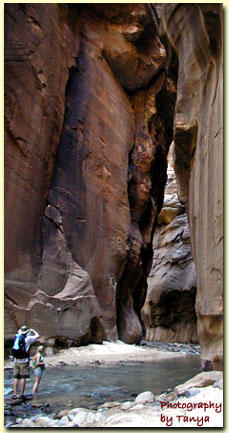
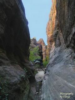
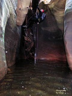
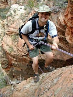
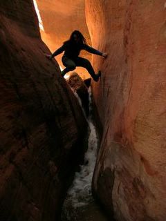
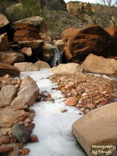
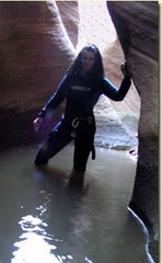
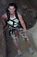
Red Cave is a magnificent,impossibly narrow slot canyon canyon with curved, twisted tunnels. Canyoneers are tempted to venture into the slots, but Red Cave is a place that most can go. There is no need for ropes, but at least one in the group must be a good climber. A 4WD makes the trip much nicer, but it can be done as a long day hike if you don't have one. Upper Red Canyon is a canyoneers dream and Lower Red Canyon can usually be done by most hikers. Be careful however, the sand fills and empties making Red Cave either easy or very difficult to navigate. Never enter Red Cave without having a good climber with you.

Red Cave

Monday, November 07, 2005

Zion National Park - The Subway

The Subway


The Subway is a well known spot for photographer and beginning canyoneers. Its a pretty slot canyon that is easy to navigate, but it does require swimming through some cold pools. The pools in the summer are done without a wetsuit and that makes the hike all that more popular. The potholes and the lighting are what make The Subway something special. Water runs through The Subway splashing through the pot holes, algae grows giving a green hue to the water polished rocks below.

There is one drawback to The Subway and that's the steep, uphill hike to get out!

The Subway

Tuesday, October 25, 2005

Zion National Park - Keyhole Canyon

Keyhole Canyon


Keyhole Canyon is a tight slot canyon that is found in the heart of Zion National Park just off the Zion Mt. Carmel (highway9) Highway. Unlike many of the slot canyons in Zion this one has a quick hike leading to the entrance. Due to this and the easier rappels, Keyhole Canyon is usually considered the beginners slot canyon in Zion. The whole adventure is only a half mile and it takes about 2 hours to complete. Keyhole is cold and there are cold water swims. Although some people do brave keyhole without a wetsuit, its an uncomfortable and rushed trip

Trail Description - photos - map

Keyhole Canyon

Sunday, October 23, 2005

Zion National Park - Orderville Canyon

Orderville Canyon


Orderville Canyon is a tributary of the Zion Narrows and the canyon that most opt for after they graduate from the Zion Narrows. Many actually get a taste of the Orderville Narrows when they are hiking the Zion Narrows and notice the off shoot. However the park only allows hikers to go to the first waterfall. Going past this without the proper gear and knowledge can be hazardous to your health. Often people end up jumping and this results in injuries.

Orderville Canyon Trail
Its nice to have a four wheel drive to get to the trailhead for Orderville Canyon, but if the weather is nice a 2WD can make it. Follow the trail description from the link below and enjoy. Orderville Canyon is one of the most dramatic slot canyon adventures in Zion National Park and the best part is that almost anyone in good condition can enjoy this hike without having to have technical canyoneering skills and rope management skills.

Orderville Canyon

Thursday, October 20, 2005

Zion National Park - Zion Narrows

Zion Narrows


The Zion Narrows Trail is the one trail that just about everyone that knows of Zion National Park has heard of. We got to play in the narrows a couple of times this year, but did not do the entire hike from Chamberlains Ranch. We will have to put that on our todo list for this spring. We did go through from Mystery Springs to the Temple of Sinewava while the upper narrows was closed. Its was flowing heavy and it was a swimmer even in the short section we went through. Later in the season we again got to exit out the narrows when we did Orderville Canyon. The Narrows deserves its name as one of the most incredible hikes anywhere.

Zion Narrows

Sunday, July 31, 2005

Zion National Park - Parunuweap

Parunuweap with Chris Draper


Chris Drapers Blog about our Parunuweap and Fat Man's Misery hike a few weeks ago. :)

Outdoor Show with Chris Draper

Wednesday, July 27, 2005

Zion National Park: West Rim


This weekend we hiked the West Rim in Zion National Park. The hike is usually done as a backpack, but we opted to do it as a quick day hike instead. My hiking partners for the day were Bo Beck and Tim Tabor. We started early and got our car shuttle started. We parked one vehicle at the Zion Canyon Visitor Center and another at the Kolob Terrace where the trailhead for the West Rim is located. The trail begins with a even to gradual up and down hike through the forested path of the West Rim from Lava Falls. After Pototo Hollow the trail steepens as it reaches to Scouts Outlook. If you have never hiked out to Angels Landing don't miss this chance. After Angels landing the last couple of miles is a downhill trek into Zion Canyon. If the shuttle is running jump on and catch a ride back to your vehicle. If you hike this after the shuttles shut down for the season be sure to park at the Grotto instead of the visitor center.

Friday, July 22, 2005


Tanya in Echo Canyon Slot Canyon in Zion National Park.

Zion National Park: Echo Canyon

I had done Echo Canyon before in 2004 at the end of a six year long drought and my 3 year old son, my husband and I just walked a large section of it. This time through we swam and made our way through cold pools of water and there were some fun raps and downclimbs. We wore our wetsuits and were again comfortable. The water was not as cold as Das Boot (we did this the day after doing Das Boot) but we were glad we had on suits. It was darker in Echo Canyon, and although I did not realize it at the time, it was clear when I looked back at my photos. Echo Canyon, like Das Boot, is a narrow wet canyon with a lot of fun downclimbs. To find it hike up from Weeping Rock past the entrance to the East Rim Trail or Hike up from the East Rim Trail and go up a ways toward Observation Point. The complete trail description is on my website. http://www.zionnational-park.com This canyon I give another thumbs up!

Bo avoiding the water in Behunin Canyon in Zion National Park.

Zion National Park: Behunin Canyon

Bo and I ventured into Behunin before it got too hot and while it was hot enough that we would not mind some cold water. Behunin is a wide wash located about mid-way up the West Rim Trail from the Grotto. It was an enjoyable hike into the canyon with some long raps throughout. The trail ends at the Middle Emerald Pool area in a rock pile. From there is a nice easy jaunt down to the Zion Shuttle.

The bushwacker in Das Boot

The Subway and Das Boot

This was a fun weekend where my hiking partner, Bo Beck, and canyoneer Shane Burrows did Das Boot and The Subway. Bo brought along another friend who likes to go nameless on the net, but most know him as the bushwacker. Das Boot is an exciting narrow slot with many fun downclimbs that opens up into The Subway. The water is cold in Das Boot so a wet suit is needed even in mid-summer. Bo and I wore 5/7mm suits and we were comfortable. Shane is use to going faster and wore a 3mm suit but I stop and take a lot of photos so Shane's teeth were chattering. Das Boot is a great slot and one of the top on my list. If you attempt it be competent at downclimbing since the raps are short, awkward and downclimbing is usually done instead in many places in the slot. Shane Burrows writes the http://www.climb-utah.com web sit and of course you can find the trail descriptions on my site as well.

http://www.zionnational-park.com

Tuesday, July 05, 2005


Dave Webb, Chris Draper, Bo Beck, Cliff, Jamie, Mason, Kyle and Dave's brother resting in Parunuweap.

Parunuweap and Misery Canyon

Parunuweap and the Barracks are without a doubt my favorite place in the world. The hike getting there is an ideal adventure with a Zion National Part start, one of the funnest slot canyons anywhere and warm spring at the end! The East Fork of the Virgin River (Parunuweap Canyon) is as impressive as the Zion Narrows but situated in a remote and wild environment. I got to finally meet Dave Webb from Utah.com who I have been talking to about hiking together for almost a year! He brought his brother and his brothers son and radio talk show host Chris Draper. We all hung out in Mount Carmel Junction for the night and set out on our trip after Chris's early morning Saturday Outdoor Show on KSL. He is able to do this by a satellite phone. My hiking partner Bo Beck went with us and one of his co-workers and his friend caught up with us at Fat Man's Misery.

Dave put a video of some of the fun highlights of the hike on the net. People here at work keep teasing me about doing the dog paddle through the water. ~laughing~

Dave's Pages and the Video
http://utah.com/travelheadlines/
http://www.redrockadventure.com/video/misery.html

Thanks Everyone! It was a great trip!

Monday, July 04, 2005


Tanya rappin' into the Zion Narrows from Mystery Canyon.

Tuesday, June 21, 2005


The Bridge Mountain arch in Zion National Park.

Joe Braun rapelling down the chimney of Bridge Mountain in Zion National Park.

Bo Beck climbing the chimney of Bridge Mountain in Zion National Park.

Bridge Mountain - Zion National Park

Here are a couple of photos of the hike. The first is Bo Beck climbing the chimney and taking the rope up for those of us that are less skilled in climbing and the next is the brige itself. The mountain is often also called Crawford Mountain and the arch, Crawford Arch.

Tanya in Behunin Canyon in Zion National Park.

Zion National Park

The weather warmed up and I got busy, but I am still out pounding the trails every week. Since my last post my hiking partner Bo Beck and I have gone Canyoneering in Behunin Canyon in Zion National Park, we have hiked to Bridge Mountain In Zion and we did a 20 mile hike from the East Rim Trail in Zion, to Cable Mountain, Deer Trap Mountain and ended at the Weeping Rock parking lot. The hikes were outstanding and I promise posts and pics to come!

Saturday, May 07, 2005


That elusive towering white hoodoo of the Grand Staircase-Esclante National Monument

Those white hoodoos in the Grand Staircase Escalante

We went hunting for that elusive white hooodoo that is often used to promote the Grand Staircase Escalante National Monument. We found it just six miles from the town of Big Water, Utah. The twelve mile round trip hike is an enjoyable one through a riverbed. However, the water is intermittent, so dont count on it year round.

The waterfall at the end of Spring Hollow. Don't ask about Adventure Jeep. It's a Joe and Bo thing.

Spring Hollow slot canyon on the east side of Zion Park

Like Red Hollow, Spring Hollow is a hidden treasure, located on the east side of Zion National Park. This one is not a narrow slot, but it has its own beauty. When the water is running there is a wonderful waterfall at the end as well as a double fall up high that is seen during the hike.

Tanya stemming in Red Hollow. Red Hollow is a fun little slot canyon on the east side of Zion National Park.

Thursday, May 05, 2005

Red Hollow in East Zion

"This is the most incredible slot canyon I have ever seen. What a great, I mean really great, easy to access, unbelievably awesome slot canyon. I'm ready to get back in there. The water coming thru made it even more awesome than I can imagine. Gave it the feel of hiking Kolob Creek in Zion Park, without having to spend the entire day working at it."
- Bo Beck

This is a great little slot adventure, that is idea when the water is running. Since the water is from snow melt early spring is the best time of year to go. If steeming your way through a narrow slot is fun, then this canyon will give it in spades with little effort to get to the canyon itself. There are no access issues which makes it all the better and there are no permits needed since this is outside of the parks.

http://www.zionnational-park.com/east-zion-red-hollow.htm

Thursday, April 21, 2005


The top of the North Guardian Angel in the Kolob section of Zion National Park. This is a 5th class scramble and rope and climbing skills are required.

Monday, April 18, 2005

Kolob: North Guardian Angel

This was a great climb. The weather was warm, but we were concerned there would be snow on the face of the entry. We hiked up to the North Guardian Angel and sure enough there was. We decided to go for it anyway and chose a route to the left of the usual crack. It was not bad at all, but we did have to still cross a couple of snow sections.

Bo Beck, my hiking partner led the way. He tied in and took the rope up the side of the mountain. I was terrified of him doing this but he said its a breeze. He took off up the side of the moutain (a fall here would be deadly) with his HUGE backpack on. I shook my head and decided that since he does teach climbing and he is a Zion search and rescue veteran I need to just trust he won't get hurt. So I pulled out my camera and starting shooting. He threw the rope down and I climbed up, but he had the rope secured and I was totally safe. At the same time three other guys were climbing up the mountain side. I found this unusual that we had chose the same day to climb since when we got to the top and looked at the log it is obvious that few have ever climbed the North Guardian Angel. The peak is on some list hoewver as one of the top 100 peaks one needs to climb, so its getting more attention lately.

Bo had done the peak once before, almost one year ago. Our friend Ram had done it 13 times! I like a little more variety in life, but that is quite the accomplishment. We climbed the rest of the mountain in the same manner. We all got to the top and signed in on the book. (the book is modly and needs someone to bring up a new jar to put it in!)

On the way down we all went together. We had a hand line and climbed down to the ridge. The snow had melted quite a bit but we were stilll unable to go down the crack. The descent was actually easier than the ascent.

This was another great trip with my best friend Bo. I hope to do many more!

Monday, March 21, 2005


The arch found along the North Fork of Taylor Creek in the Kolob Canyons section of Zion National Park

Friday, March 18, 2005

North Fork of Taylor Creek in Kolob Canyons of Zion Park

North Fork Taylor Creek


This was a nice hike but the highlight for us was spotting another arch. We seem to be into arches lately. This one is high on the cliff and can only be seen from certain angles. We were lucky to see it. We asked later at the visitor center and it was not named so we gave it a Brazilian name, Pico Rosado (pink spire) in honor of Bo's Brazilian wife. This hike is 7.5 miles (round trip) along an unmaintained route following the North Fork of Taylor Creek. The route begins at the Middle Fork of Taylor Creek Trail, which I had done before, but Bo had not. Take the middle fork to the first cabin and head to the left.

There is a fairly good path to take during the first section after the cabin, but then as it disappers just follow the stream bed to the end of the canyon.

Sunday, March 13, 2005


Zion Search and Rescue member Bo Beck and Kane County Search and Rescue Vice Commander standing on top of Jug Handle Arch in Zion National Park.

Friday, March 11, 2005

Jug Handle Arch

This was an enjoyable day with my friends Dean Kurtz and Bo Beck. We met in Zion, 2 miles east of the little tunnel. After a quick map reading lesson by Bo we started up the hill. Bo was going to have me use the map to find the arch today, but he cannot resist leading, which I like it that way! We started up the hill towards the entrance to the Keyhole Slot Canyon. The path was well used to the top of the saddle. Its a fairly steep hike all the way to the arch, so dont go expecting a leiusrly walk. The entire hike was only 1.2 miles one way, but it took about 2 hours. We stopped and talked and took a lot of photos along the way however.

At the top of the mesa it's a quick .2 miles over to the arch. The Jug Handle Arch is a propped arch, which hikers can actually walk right out on top of. Don't make the mistake I did and climb down the side to get a better photo. A huge rock went down the side with the slightest touch of my foot. The whole mountain side is unstable with all the rain we have been having. I was lucky to have been holding onto a tree. My search and rescue friends were not thrilled when they heard the rock fall and saw where I had snuck off to. They made a hand chain and held onto me just incase the tree decided to give way as well.

We decided to go back a different way. We hiked down to the ridge and went to the western side of that, around the top, then to the eastern side of the ridge. There we found nice pot holes of water which were visible when standing on top of the arch. Bo jumped into the water for his usual cold water dip. Fairly odd considering he wants no part of cold water canyoneering. We all got a kick out of Bo and took a couple of photos before heading to see the arch. Its actually a better view from down below the arch, but standing on top is always nice.

In the morning we are headed out to Kolob Canyons. The weather is suppose to be 70 degrees. Spring is comming quickly.

Spring is in the Air

I was getting my backpack ready for my weekly hike and throwing my winter and rain gear to the side felt so good. The only problem is that my pack is empty now. I am sure it was not that big at the start of the season! The coats, pants, socks, shoes and all the extra I have packed all winter have stretched my pack to enormous proportions. Soon the canyons will be acceptable for us warm weather canyoneers and the empty space will be filled with a harness, ropes, helmets and such. In the mean time I plan to enjoy my light weight pack for the day.

Saturday, March 05, 2005


Checkerboard Arch is a fun hike on the east side of Zion National Park. This is not a maintained route and gets little foot traffic.

Checkerboard Arch - Zion National Park

This last weekend we decided to go and find an arch near Checkerboard Mesa that my friend Gabriella spotted when hiked to Parunuweap. It was a cool February day and Zion has been having record amounts of precipitation. Even the start of the hike was gorgeous with water running in and through the many potholes. We started down the slot between Checkerboard Mesa and Quilt Mountain trying to avoid the muddy parts. We kept our feet pretty dry all the way to the arch. This is not a trail, but an unmaintained route crossing back and forth across the drainage. There is a nice view of Parunuweap in the distance from the saddle. To find the arch hike to the southern end of Checkerboard Mesa and then to the left. There is a path there and a few cairns. On a topo map look for 6273. This is the mountain the arch is on. It’s a large freestanding arch on the left side of the mountain. We took an alternate route back instead of retracing our steps. We were not sure if the slot would allow it, but we took our chances and we were lucky. This exit is only for hardcore hikers. Expect bushwhacking and an uphill hike until almost at the end then it’s a steep descent. The exit is 2 mile long like the approach was.


The water roars down into the lower Emerald Pool. Zion National Park has had rain and snow in abundance and its not letting up yet.

Sunday, February 13, 2005

Rockslides along the Switchbacks

There seems to be one area that is having problems. Its lower down on the switchbacks as you can see from the photo. This rock fall was huge. When we were out hiking today on Observation Point we heard something that sounded like a huge gun going off. We decided it was a rockfall.

West Rim to West Rim Springs

This was a cold day, but the sky was clear and the sun was shining. We breezed up to Scouts Outlook where the West Rim Trail and Angels Landing split. I was feeling pretty good about our time until Bo mentioned that he RUNS up to Angels Landing when by himself in less than 1 hour. That is impressive. I seem to forget how steep this trail is each time until I get on it again. The trail was clear and in good condition for our hike, but we ran into snow just prior to Little Sibera. After heading in there I could see how it got its name. The area looked like it rarely saw a drop of direct sunlight. The path was ice and snow which was not too bad until we got to a narrow path with a steep drop off on one side. We put on the crampons and headed up the trail. We made it across without falling, but I would not reccommend that anyone does it. It was pretty scarey. After we got out of Little Sibera the path was a again clear of snow and nice. Bo pointed out the head of Behunin Canyon to me and we laughed about Shane's thoughts on the canyon. We headed up the mountainside trail and marveled at the many waterfalls dripping down onto the trail. The rains this year has made Zion even more spectacualr than usual. When we got to the spring at the top I laughed to see a little hole in the ground with a little water. Not much of a destination but the view from the spring area is gorgeous. This is where one can camp when doing the West Rim backpack.

Observation Point

Today we hiked to Observation Point. We had planned to hike it when we did Hidden Canyon but there was far too much ice and snow to go all the way. Today we had better luck. It had been raining a good deal rather than snowing and we found most of the trail to be nice and dry. At Echo Canyon however there was so much water in the usually dry wash that we had to climb the rocks around or go wading through the ice cold, knee deep water. We chose to climb. At the very top of the Mesa we ran into slushy snow and lots of red mud. It was cold up on top, but the rest of the way it had been a nice warm hike for a February day.

I have never seen Echo Canyon looking so beautiful. In fact the entire way up the hike I was mezmerized by the colors of the rocks. Bo seemed to also enjoy the waterfalls everywhere and the moss that was unusually green and healthy looking. Most of the lower trail past Hidden Canyon had water running on it. There was some trail damage from all the floods and rains this winter, but the trail was still in pretty good condtion.

We took a lot of time on this hike taking pictures because it was so unusally colorful and wet! The water in Echo Canyon was flowing deep and we could hear the water rushing through the canyon during a lot of the hike. It was a great day in Zion and a fun hike with my Best Friend Bo. We got to meet two ladies from the St. George area that were a delight and they breezed around that rock climbing area. I was impressed.

Hidden Canyon

Hidden Canyon is always fun when in the mood for some good exercise. A total of 2.2 miles roundtrip where the first part is very steep, then once in the canyon its a pleasureable walk down a mostly dry wash. The hike begins at the same trailhead as the Weeping Rock and East Rim trail. This is a unique hike through side ravine between Cable Mountain and the Great White Throne. The official hike ends at the first pothole full of water, but the best part is after this. We went in the winter and crossing over the pothole area was dangerous due to the ice. Hopefully when you go you wont have to deal with the ice. I drew a huge sigh of relief after I passed it. The rest of hike is boulder hopping and walking through a sandy wash. If there has been a lot of rain or snow there might be water in there as there was when I went. In the photo album on the website there is a mix of summer and winter photos. Keep your eyes peeled for the freestanding arch. It will be on your right side when hiking into the canyon. Its hard to see since the green moss blends it into the mountain and there are leaves and such hiding it. I have passed it numerous times and never saw it! It's right across from a huge greenish wall. Before long the hiking becomes impossible without climbing and rope skills. Turn around here and be careful if you encounter ice again near the pothole.

Sunday, January 23, 2005


That is my gorgeous husband in Shelf Canyon.

Shelf Canyon - East Zion National Park

We have had a full day of hiking up to Spry Canyon, but we try to add one more hike to our days agenda before the winter night closes in on us. We drive up towards the big tunnel to find Shelf Canyon. It is the first drainage on the east side of the 1.1 mile tunnel, the Zion Mt. Carmel Tunnel. Shelf Canyon is a great hike through an east side drainage that includes some easy boulder hopping and slickrock climbing. The four of us head up the sandy bottom of the drainage, quickly crossing the slickrock obstacles. Glancing up we notice crossbedding that is a rare find. Toward the end of the hike the walls close in to a narrow slot canyon until the path completes at a series of shelves. Its late in the day and we toy around with the idea of climbing up the obstacle at the end, but decide its better left for a day when we are equipped with technical gear and the days are longer.


Playing in the snow on the east side of Zion National Park. Snowshoes and Crosscountry skis are ideal at the higher elevations of the park.

Snow shoeing in Zion National Park

The rains were pouring down, flash flooding all around in Zion National Park and the nearby towns, but East Zion was covered in snow. Two of us wanted to try out the snowshoes and 2 wanted to try cross country skiing, but the weather decided for us. What a better time to head for the hills of Zion National Park and try out snowshoes or skis! It was wonderful.

We took North Fork road up toward the Ponderosa Ranch where there is a road out to 2 different trails. One is East Mesa and the other is to Jolly Gulch. We opted for the shorter Jolly Gulch this day because the snow was getting drenched from the rain.


The Emerald Pools system of trails is now open with the exception of the Lower Pool. This is the damage to the trail on the far edge toward the Kayenta trail. Passing under the middle pool is not possible until the damage is repaired.

Thursday, January 13, 2005

Zion Park after the rains and flash floods

Yesterday in Zion National Park the skies were exceptionally blue and air, although some of the cleanest we can hope for, was unusually fresh. The sandstone was saturated, bringing out the brightest of color in the rock. Moss stood up, thriving as if it were spring. Waters roared, audible from quite a distance. River edges tipped with water that still threatened to pour over into the fragile ecosystem of Zion, disturbing the balance set by the blazing heat of many years.

It was a wonderful photo day, as the Clear Creek roared in East Zion Park and Pine Creek flooded through its narrow passage. Even Checkerboard Mesa had a strong torrent of water in its foreground. Today I wish I were there again, but the weekend will come soon enough.

The rocks fell along the second switchback from the bottom on January 12, but traffic was directed around the rocks. The slides are getting to be far too common, be careful along the switchbacks area.

Rock Slides close some sections of Zion

January 12

The Zion Canyon Road is still closed past the Zion Lodge and the trails in Zion Canyon, with the exception of the Court of Patriarches are closed.


January 11th

The Zion Canyon Scenic Drive is closed north of the lodge, probably for the rest of the day. There was a large slide and rocks have to be moved. Large rocks will have to be blown up. The park did close off the road anticipating this so there should not have been anyone trapped this time and no injuries.

There was a rock slide at the 2nd switchback from the bottom, along the Zion Mt. Carmel Hwy, but rangers directed traffic around the rocks and had it cleaned up within a couple of hours.

The lower emerald pool roars and the water from Heaps Canyon pours into it during an impressive flash flood in Zion National Park.

Wednesday, January 12, 2005

Zion Canyon Scenic Drive is closed due to Landslide

The Zion Canyon Scenic Drive is closed north of the lodge, probably for the rest of the day. There was a large slide and rocks have to be moved. Large rocks will have to be blown up. The park did close off the road anticipating this so there should not have been anyone trapped this time and no injuries.

Flash Floods rage in Zion National Park

Spry Canyon is pouring hard into Pine Creek, there is a nice fall above the Great Arch, another by the Pine Creek exit, There is one to the side of the Streaked Wall and East Zion Park is busting with them. Clear Creak, Pine Creek and Upper Pine Creek, Keyhole are all blasting.

In Zion Canyon waterfalls are all over. Employee Canyon, behind the Lodge, Behunin, Temple of Sinewava there are many ....

There was a nice one just to the side of the Great White Throne. Weeping Rock was Roaring Rock!!!! ---

The Virgin was to the brim and water was deep in the fields by the Lodge.

The rock falls along the switchback are getting crazy and there were some along the Zion Canyon road.

The East Fork of the Virgin in Mt. Carmel Jct. is to the brim and raging!

Its gorgeous in there and the Virgin River is flooding at a 100 year record!

The Zion Canyon Road was closed for a while yesterday, hopefully it will be opened up today and there will be no sign of the landslide that trapped visitors in the Zion Lodge area about 10 years ago.

Tuesday, January 11, 2005

Lower Emerald Pools - Zion National Park

The Lower Emerald Pool trail is an easy and fun trail for the entire family. Even wheelchairs and strollers can easily make it down this one. The reward at the end of the path is a beautiful waterfall. This is not your usual waterfall, cut a giant alove with water weeping down splashing on the rocks below as you are able to walk beneath it. You will get a little wet, but not too bad. Be carful when starting the Emerald Pools trail if this is the path you want since the middle pool trial begins at the same place.

Today I got the opportunity to go with my friend Bo during a crazy rain storm in Zion. We had a blast as the water poured from the sky and from the waterfall. The hanging gardens under the falls are beautiful and the black streaks of the desert varnish give a nice look to the alcove. Bo took the photos posted on the page of the Lower Emerald Pool and I thought it was great so I used. it. Once you are past the pool you can go back to the Lodge area, continue in the same way and go to the grotto on the Kayenta Trail or go to the upper pools.


Scoggins Wash in Zion National Park is a nice winter hike that is located on the far southside of the park where it is warmer. The hike heads toward the Altar of Sacrafice and it has some fun bouldering. The water souce is not reliable however.

Monday, January 10, 2005

Scoggins Wash - Zion National Park

Scoggins Wash shares the trailhead and the first part of the hike with the Coalpits Trail. This section of the hike was named coalpits after the basalt rock formation that look similar to coal. The elevation at the trailhead is the lowest elevation in Zion National Park at 3666'. Huber Wash, Scoggins and Coalpits Wash are all drainage's of the Virgin River and are found on the south side of Springdale in the hottest section of the park. This part of Zion is not as scenic as the other sections and to top it off there has been a lot of building near the trailhead. The first part of the trail passes under powerlines. With this said these southwestern trail are still a delight since they can give the option to hike in Zion in the dead of winter when the other trails might be covered with ice or its too cold. The only winter drawbacks is that it uncomfortable to hike Scoggins if the ground is too wet. Much of the hiking is along a dirt path with some scream crossing and bouldering. The bouldering is pretty simple and its at the far end of the hike before the trail meets with the Chinle Trail. To find the trailhead drive 7.3 miles past the south toll gate. You should see the Coalpits Wash sign and a small dirt turnoff. Park there and located the hikers gate.

The first part of the hike is pretty uneventful, but before long you get to hike along the water and cross it once in a while. Look for the Scoggins and Coalits Wash junction which is near the 2nd basalt formation. You can choose either direction at this point. Today we choose Scoggins. This was a great choice since the wash had some water flowing and it was a delightful day. Near the end where the big boulders croweded and the Zion Park monoliths came close into the view the hike was quite nice. After the boulders the Chinle trail juction will occur. The last part of the Scoggins hike is fun with some bouldering so if you are going to return on the Chinle Trail you might want to go and do the last mile or so of Scoggins first.


To continue down Scoggins Wash follow the wash to where is joins a tributary. Follow Scoggins headed northeast. Scoggins Wash is a tributary of Coalpits that drains below the Altar of Sacrifice. Keep headed towards this monolith.

The Altar of Sacrafice is a unique monlith with 2 red blood like streaks running down from the top. Out of the Chinle and Coalpits hikes this one is my favorite, but it would not be as pleasurable if there were not water flowing in it.

Thank you Bo for another wonderful hike!

Sunday, January 02, 2005


Coalpits wash is a fun winter time hike. The water is mostly frozen, but the air was nice and warm.